Entry Points:

About Routt County
Routt County occupies 2,368 square miles in the northwestern area of Colorado, on the western slopes of the lofty peaks of the Rocky Mountains. The lowest elevation in the county is 6,230 feet, and many peaks reach above 10,000 feet. Much of the eastern boundary follows the Continental Divide and high mountains cover its southern borders and much of the northern reaches. Three rivers flow westward out of the mountains, the East Fork of the Williams River, The Yampa River, and the Little Snake River which parallels the northern border.
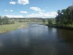
The Yampa River flows through the heart of the Routt County. It actually begins at Yampa, in the southern part of the county, then flows north to Steamboat Springs, where it turns west. Near here, the Elk River joins it, flowing from the north. The Yampa River continues west to meet the Green River near the Colorado-Utah border.
Routt County's population was 19, 690 in the year 2000. The county seat is Steamboat Springs. It was organized on January 29, 1877, being split off from Grand County. In 1911, it was divided, with the western portion forming Moffat County. It is named after John L. Routt, who was the governor of Colorado when it became a state. It borders Wyoming on the north.
U.S. Highway 40 follows the Yampa River until it begins it's climb to cross the mountains. Colorado Highway 131 traverses the southern section of the county, heading southward from near Steamboat Springs.