Entry Points:

About Montezuma County
Montezuma Valley lies at the center of Montezuma County. To the south, the cliffs of Mesa Verde overlook the valley, covered in juniper trees and dotted with the cliff-dwellings of prehistoric indians. Sleeping Ute Mountain rises to nearly 10,000 feet in elevation to the west, so named for its resemblance to a sleeping Indian. The valley floor is hilly and slopes generally upward toward the north. A wide gap between Mesa Verde and Sleeping Ute Mountain passes into the lower deserts to the south. At about 6,000 feet in elevation, Montezuma Valley enjoys adequate moisture, and is checkered with farms and dotted with trees.
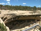
Mesa Verde National Park sits atop cliffs where dozens of ruins left by prehistoric Indians have been discovered, including the famous Cliff Palace, where hundreds of Indians once lived under the shelter of a large overhanging cliff.
Along the western side of the county, north of Sleeping Ute Mountain, a series of steep-walled canyons has cut into the floor of the valley. The fields of farmers end abruptly at the edge of a drop that ends in a narrow canyon hundreds of feet below. This rugged area has been set aside as Canyons of the Ancients National Monument, and a number of Indian ruins here are protected in the older Hovenweep National Monument.
The diverse topography and geology of Montezuma County are remarkable. The flat top and angular corners of Mesa Verde make a stark contrast to the rounded slopes of Sleeping Ute Mountain. The large number of canyons cut into plateaus is surprising, both atop Mesa Verde and in the Canyons of the Ancients area. Rivers in the county also follow surprising courses. The Dolores River flows out of tall mountains to the east, and reaches the north side of Montezuma Valley. Then instead of taking the easy course down into the valley, it flows northward, cutting a deep gorge into the gradually rising plateau in its way. McElmo Creek, flowing past Cortez in Montezuma Valley, instead of following the valley's drop to the south, takes a sudden turn to the west, following a narrow canyon cut right at the feet of Sleeping Ute Mountain.
Montezuma County lies in the southwest corner of Colorado, sharing borders with Utah on the West and New Mexico on the south. It sits kitty-corner from Arizona, and the Four Corners Monument was built to mark the only spot in the United States where four states touch at one point. 23,830 people now inhabit the 2,037 square miles of the county. Cortez is the county seat and largest city. U.S. Highway 160 crosses the county east to west, and U.S. Highway 491 heads north and south.