Entry Points:

About Pleasant View
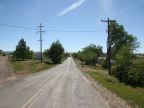
Pleasant View is a small town located in the farmland of Montezuma Valley. The valley stretches eastward for many miles to the La Plata Mountains and to the north to the Dolores River Gorge. To the southwest the land is broken up by canyons including SandStone Canyon, just to the south, and Hovenweep Canyon to the west. These canyons grow deeper and the terrain surrounding them more broken up further southwest, and the farmland disappears.
Pleasant View is located on U.S. Highway 491, which leads north to Dove Creek. and south to Cortez. The elevation is 6,900 feet. The population is too small to be included in the census, but Pleasant View does have a post office and a school.
Many Indian Ruins can be visited in the area of Pleasant View, including those at Hovenweep National Monument. The Spanish Trail also passed through this area, and was used in the exploration and settlement of the area while it was under Mexican control.
For More information
See the Wikipedia article on Pleasant View.
Street Index
|
a dirt road a street Road CC U.S. Highway 491 |